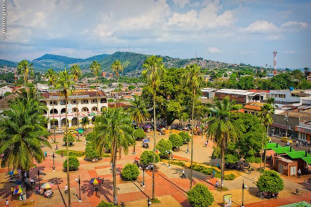
Florencia is the capital of the Caquetá department and the most important city in the southeast of the country due to its population, over one hundred years of history, and institutional development of the state. Known as “The Golden Gateway of the Colombian Amazon,” Florence was founded on December 25th, 1902 by the Franciscan friar, Father Doroteo of Pupiales (1876-1959) born in the municipality of Pupiales, Nariño, also known as José Rubén Vallejo Belalcázar before being ordained. It is located in the foothills of the Eastern Cordillera of Colombia, in the Andes mountain range, on the banks of the Hacha River, in the northwest of the Caquetá department, which gives it an environmentally privileged position as the link between the Andean region and the Amazonian region
The Caquetá region starts at the foot of the Andean mountain and ends at the Araracuara cliffs, in the heart of the Amazon jungle. Large rivers bathe the territory, all tributaries of the Caquetá River, which serves as its southern boundary. Among these rivers are the Ajajú or Apaporis, the Yarí, the Caguán, and the Orteguaza, navigable by small boats.
With the exception of the populations located at the base of the mountain range, and a few indigenous settlements on the banks of the large rivers, the rest of the territory is virtually uninhabited and covered with dense tropical rainforest, with a temperature between 27º and 29º.
- Area: 88,965 km2
- Population: 315,760
- Year of creation: 1981
- Demonym: Caqueteño
- Capital: Florencia, 112,354 inhabitants.
- Main municipalities: Puerto Rico, San Vicente del Caguán, Belén de los Andaquíes.

Limits: To the north with the departments of Meta and Guaviare; to the east with the departments of Vaupés and Amazonas; to the south with Amazonas and Putumayo; and to the west with the departments of Cauca and Huila.
Physiography: The department’s territory ranges from the Andean foothills to the Araracuara mountain range in the heart of the Amazon rainforest. Two regions can be distinguished: the foothills, with some reaching heights of over 400 meters above sea level, and the region covered by the tropical humid jungle.
Hydrography: Caquetá River, with its tributaries the Pacayaco, Sapoyaco, Fragua, Yuruyaca, Canela, Solano, Orteguaza, Consaya, Aguablanca, Rutuya, Caguán, Yarí, Jerú, Mirití, Paraná, Apaporis, Cascabel, Mocoa, Mandier, Mecaya, Nasaya, Cahinari Curé, Gravatana, and Arapa rivers.
Economy: The foothills region offers fertile lands that are being utilized for crops such as rice, banana, corn, cassava, cocoa, and sugarcane. The forestry production is diverse and rich in woods, resins, medicinal plants, and rubber. There is extensive cattle raising and a well-developed rubber exploitation and cultivation.
Tourist sites: Picachos National Park, Chiribiquete.
Pre-Columbian Period
Before the Spanish conquest, these lands were occupied by numerous indigenous groups, many of whom still exist today. Among them, the Andaquíes, Koreguajes, Karijonas, Tamas, Macaguales and Huitotos stand out. Part of their cultural legacy is represented by petroglyphs, which are located mainly in the municipalities of Florencia and San Vicente del Caguán.
The dense Amazon jungle that covers much of the territory has favored the survival of these groups, although the rubber exploitation of the first half of the 20th century brought about the persecution and extinction of many ethnic groups.
Colonization
During the conquest period, the territory was traveled by Hernán Pérez de Quesada and George Huhermuth, but it was not colonized due to the difficult conditions of the environment and the limitations of the time.
During the colonial period and the early years of the Republic, the Caquetá belonged to the province of Popayán; in 1821 it became part of the departments of Boyacá and Cundinamarca; later it was the National Territory. In 1857, the Caquetá returned to what is now the department of Cauca, until 1909, when the Caquetá was converted into an intendancy and later into a commissioner in 1910.
From its extensive territory, which initially covered the entire region south of the Guaviare River, successive Amazonian intendencies and commissioners were detached. The colonization of the Caquetá actually began in 1930 due to the Colombian-Peruvian War. The extraction of rubber as the driving force of the economy at that time is narrated in the novel “Toá” by César Uribe Piedrahita.
The colonization process received support from the state from 1964 through INCORA. By the 2000s, the colonized area in the piedmont reached over three million hectares. The constant growth of the population and the economy led to the creation of the Intendency through Decree No. 963 of March 14, 1950.


